Description
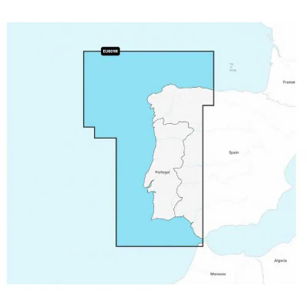
NAVIONICS NAEU009R-Portugal And Spain Northwest EU009R-Regular Map
Elevate your marine adventures and navigate with unparalleled confidence along the stunning coastlines of Western Europe with the NAVIONICS NAEU009R Navionics+ Regular map. Specifically designed for boaters, anglers, and sailors exploring the waters of Northwest Spain and Portugal, this advanced cartography solution transforms your compatible chartplotter into a powerful navigational tool. Experience a new level of situational awareness, whether you are planning a coastal cruise, seeking out the best fishing grounds, or carefully navigating intricate harbours and estuaries.
This all-in-one chart provides the essential data you need for safer, more enjoyable journeys on the water. Rely on comprehensive, clear, and up-to-date information to plot your course, identify navigation aids, and understand the marine environment around you with exceptional precision.
EU009R – MSD – Navionics+ Regular – Northwest Spain and Portugal.
Navionics+ is the electronic cartography standard that offers more content and the best value for marine areas and lakes the most detailed, all-in-one cartography for seas and lakes makes Navionics+ the perfect choice for boating and fishing.
Now you can have the most accurate navigation data for your navigation system, an exclusive HD bathymetric map with intervals every 0.5 m improved by the contributions of other sailors like you, and the local data published by the users of our apps.
Thousands of edits are processed at Navionics every day so you always have the most up-to-date charts available.
Daily updates and advanced features are included for one year.
Main Features & Key Benefits:
* Comprehensive Nautical Chart: Gain access to a robust and detailed chart layer, providing essential navigational data derived from official and private sources.
* SonarChart™ HD Bathymetry: Discover the hidden details of the seabed with an extraordinary high-definition bathymetric map. The 0.5m (1 ft) contours provide a superior depiction of bottom structure, perfect for locating fishing spots, anchorages, and navigating shallow areas.
* Community Edits: Benefit from valuable local knowledge shared by fellow boaters. Access a wealth of localized points of interest, including seasonal buoys, lights, rocks, boat ramps, and other marine information that is constantly updated.
* Dock-to-dock Autorouting: Simplify your route planning. This breakthrough technology calculates a suggested path from a real start point to a real end point, considering chart data and navigation aids to guide you through channels and waterways.
* Advanced Map Options: Customize your chart view for enhanced clarity. Adjust contour density, highlight shallow areas, target a specific fishing depth range, and reduce clutter to focus on what matters most for your current activity.
* Plotter Sync: Effortlessly connect your compatible chartplotter to the Navionics Boating app on your mobile device. Transfer routes and markers, and update your chart layers wirelessly for ultimate convenience.
Technical Specifications:
* Product Code: NAEU009R
* Coverage Region: Western Europe
* Specific Coverage Area: Detailed coastal and offshore coverage of Northwest Spain and Portugal, from Villano-Sisargas, Spain to Peniche, Portugal. Includes major estuaries and ports such as Ria de Arousa, Ria de Vigo, Porto, and Lisbon.
* Format: Data provided on MicroSD card (MSD).
* Compatibility: Designed for use with a wide range of the latest chartplotter models from leading manufacturers including Lowrance, Simrad, B&G, and Raymarine
Reviews
There are no reviews yet.