Description
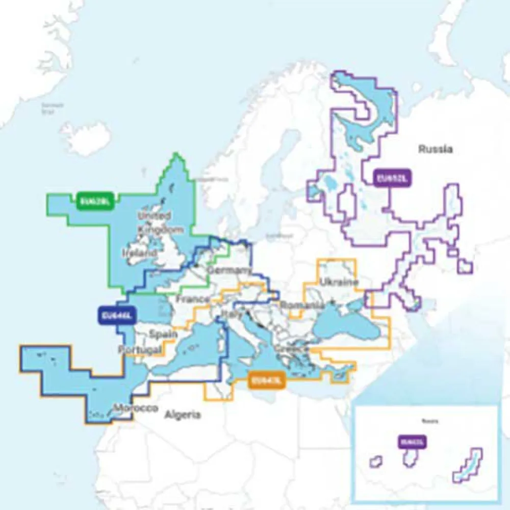
GARMIN NAEU643L Mediterranean & Black Sea Navionics®+ Micro SD/SD Card Map
Category: Electronics
Subcategory: Cartography
Navigate the historic and breathtaking waters of the Mediterranean and Black Sea with absolute confidence and unparalleled detail. The GARMIN NAEU643L with Navionics®+ cartography is the ultimate all-in-one marine mapping solution, designed to transform your compatible chartplotter into a powerful navigational tool. Whether you are charting a course for offshore passages, exploring intricate coastal archipelagos, or fishing in inland rivers and lakes, this advanced map card provides the rich, integrated data essential for safe and successful voyages across both Western Europe and Eastern Europe.
Get the world’s No. 1 choice in marine mapping¹ — with the best, most up-to-date Navionics®+ cartography on your compatible chartplotter². For offshore or inland waters, this all-in-one solution offers detail-rich integrated mapping of coastal waters, lakes, rivers and more. Get SonarChart™ 1’ (0.5 meter) HD bathymetry maps, advanced features³ such as dock-to-dock route guidance technology⁴, live mapping and Plotter Sync to provide wireless access to daily updates. The Navionics® Chart Installer software also ensures the freshest chart data every time out. Navionics route guidance solutions give you a suggested path to follow through channels, inlets, marina entrances and more. Multiple shading options aid in shallow water navigation and make it easy to highlight a target depth range for the best fishing spots.
This premier cartography empowers every mariner, from the professional sailor to the recreational boater. The high-definition bathymetry of SonarChart™ reveals the seafloor in extraordinary detail, perfect for identifying promising fishing structures, ledges, and drop-offs, or simply for understanding the underwater topography for safer anchoring. With dock-to-dock route guidance, planning your journey from one marina to the next becomes a seamless and automated process, calculating a suggested path that considers chart data and potential navigation hazards.
Stay current and confident with the ability to access daily updates wirelessly. The maritime world is constantly changing, and with Plotter Sync and the Navionics® Chart Installer, you can ensure your charts reflect the latest notices to mariners, buoy changes, and surveyed data. This dynamic capability means you are always navigating with the most accurate information available, enhancing safety and peace of mind on every trip. Enhance your situational awareness with multiple shading options that make it intuitive to identify shallow areas at a glance or to pinpoint specific depth ranges critical for your fishing or sailing objectives.
—
Technical Specifications
* Product Code: NAEU643L
* Format: Micro SD/SD Card
* Coverage Region: Full Mediterranean Sea and Black Sea
* Geographic Attributes: Eastern Europe, Western Europe
* Key Mapping Technology: Navionics®+ Integrated Cartography
* Bathymetry Detail: SonarChart™ up to 1’ (0.5 meter) HD resolution
—
¹Based on 2020 reported sales.
²Compatible chartplotter required.
³Advanced features require a compatible chartplotter and an active subscription.
⁴Dock-to-dock route guidance is for planning purposes only and does not replace safe navigation operations
Reviews
There are no reviews yet.